The strongest El Nino since 1950 is taking shape in the Pacific
NOAA puts the chance at 83 percent that this El Nino passes every event in records going back to 1950. NASA satellites are tracking sea surface temperatures more than 4 degrees above normal in parts of the eastern Pacific, with the effects expected to run into early 2027.
Washington, United States · October 18, 2026
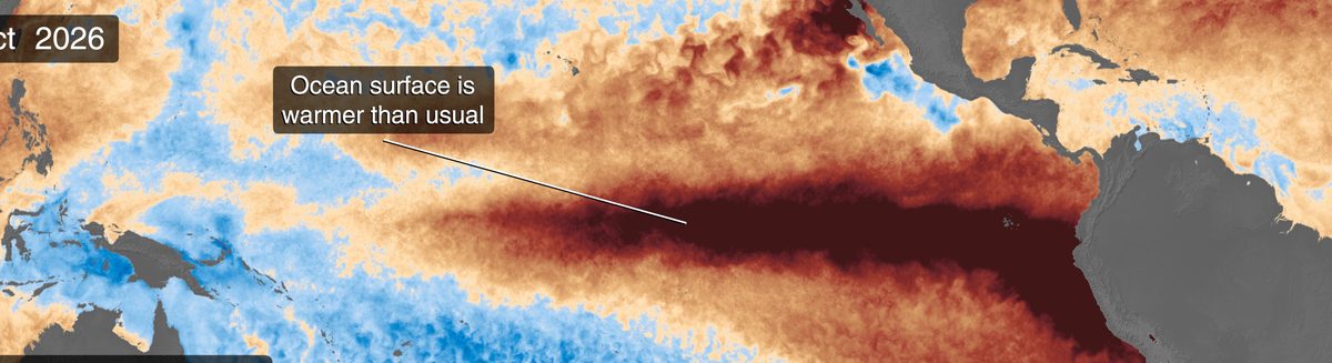
Forecasters at NOAA's Climate Prediction Center give an 83 percent chance that the El Nino now building in the Pacific becomes the strongest since 1950. The measure they use puts the seasonal anomaly for October to December at at least 2.5 degrees Celsius above normal. No event in the record, which runs back to 1950, has cleared that mark. This is not a forecast of a strong El Nino. It is a forecast of a record one, made while the event is still gathering.
The September numbers show why they are willing to say it. Sea surface temperatures in the Nino-3.4 region, the stretch of the equatorial Pacific that forecasters watch closest, ran 2.1 degrees above average. Parts of the eastern equatorial Pacific were more than 4 degrees above normal, and the warm water below the surface was more extreme still, with anomalies above 10 degrees at depth. That heat underneath matters, because it keeps feeding the surface long after a brief warm spell would have faded.
NASA's satellites are watching the same event from orbit. Its Sentinel-6 and PACE spacecraft are tracking the warming, including a Kelvin wave, a slow pulse of warm water moving east under the surface, that was first spotted in January 2026. Put the two views together and the picture is consistent: this event was visible coming almost a year out, it has arrived on schedule, and nothing in the current data suggests it is running out of energy.
NOAA expects strong to very strong conditions to hold through January to March 2027. El Nino does not bring one kind of weather. It rearranges the odds: heavier rain in some regions, drought in others, and shifts in the storm tracks that farmers, water managers and insurers price months ahead. A record strength reading does not mean record damage everywhere. It means the background pattern those plans are built on is being pushed further than it has been in at least three quarters of a century.
There is a habit of treating El Nino as a curiosity, a warm patch of ocean with a Spanish name. The better way to read this forecast is as an early bill. Harvests, reservoir levels, winter energy demand and flood risk on several continents will all be negotiated against this event over the next six months. The ocean has already made its move. Everyone downstream is now working out what it costs them.
The Briefing
The day's world, market and sport, measured and in your inbox before breakfast. One email, no noise, free while we build it.
Subscribe by emailSubscribing opens your email app with a note to [email protected]. We never share your address.